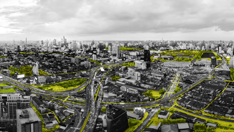
Landscape Vision to re-connect the city’s abandon area together
The 10 KM Project is our initiative to revitalize underutilized urban infrastructure—specifically, the space beneath the expressway—transforming it into a continuous 10-kilometer park connector.
This green corridor will reconnect people to nearby parks and districts, bridging diverse land uses from transportation hubs and tourist zones to commercial, healthcare, residential, and creative districts. This project demonstrates the potential to bring life and nature back to the city by turning overlooked infrastructure into vibrant green public space. paving the way for a more sustainable and livable urban future.
Project Information ↘︎
Status
Vision
Year
2017
Award
- IFLA ASIA-PAC International Federation of Landscape Architect 2017
- World Architecture Festival X 2018
Design Director
Yossapon Boonsom
Landscape Architect
Kirin Tanglertpanya
Yossit Poonprasit
Tadchaya Bhuvanajdilokkul
Nawarat Yangsomran
Graphic Designer
Tadchaya Bhuvanajdilokkul
Pasu Nimmol
(Mor and Farmer Co., Ltd.)
Photographer
Pasu Nimmol (Mor and Farmer Co., Ltd.)
The urge to go outside and enjoy outdoor activities in a metropolis seem quite common today, as well as in Bangkok. A lot of urban people start to jog more and many Marathon events happen like never before. This movement, likewise, urge us to foresee an urban-scape which could accommodate these healthy activities, that might as well improve overall urban livelihoods. Hence, we see potentials in a large public park located at the North of Bangkok to be a starting point of the project, and continue toward the South to the inner city where the end point meets Chao Phraya River.
This 10 Km. length project, which forms an almost straight line through the city, has available resources to shift itself into a platform that can knitted people with healthier lives, unique urban cultures, and most importantly, sustainable economic development. Along this passage, Highway and multiple abandoned vast spaces disconnect the urban fabric, splitting city into two corridors.
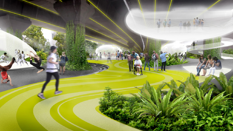
The 10 KM. project proposes an idea of re-appropriate spaces under highway, skywalk bridge, footpaths, and canal side to re-attached the urban through green ecology.
The passage surrounded by diverse landuse however each section shows
significant characteristics of the neighborhood. In order to enhance those community unique qualities, we summed up to 6 different zoning
The zoning systematic was derived from first-hand experience of the designers who take multiple running trips along the routes. From the start to finish point, the site posts numerous problems and challenges. Major problems occurs around footpaths which include; Routes tend to benefit motor vehicles much more than walking or bicycling; Under developed green area along the walkway and bike path causes over exposed to sunlight; Many of them also too narrow and obtain gnarled surface with obstacles; as well as the discontinuity of the path to mass-transit.
For this reason, we propose a strategy to develop urban environment by introducing a 10 KM green corridor that restore Bangkok’s long lost connections. First is to relink mass-transit systems of Cars-Rail-Boat while introduce alternative route such as bike path and walkway to reduce cramped in transportations. Second, Human to nature relationship where green corridor will reach each public park to create a complete green network for the city. And Lastly, the sense of Community where recreational areas were added to create communal activities through sports, playgrounds, and creative spaces. By this interconnecting, we hope to activate the pulse of local economic growth, improve living quality and set off agenda for the community center based development.
Altogether, we wholly believe in the significance of actualization for this strategy because the urban population continue to grow rapidly and the city infrastructure will no longer be able to support that, as we all have witnessed today. We hope this project will be a case study for future urban development. The decision of proposing an almost straight line of 10 KM route is to be comparing with heart rate that is deliberately dying, alike our urban is decaying. Hence, we are determine to use our practices to spark ‘The Urban Pulse’ for the city as if we use the pacemaker to charging electric currents into a body then the pulse had been brought back to life. This means to awaken millions of urban habitants for the better quality of life again.